Ada
County Corner Record Map
Index
Latitude-Longitude
/ X-Y Coordinates
Zoom
to Township/Range/Section
DISCLAIMER
The material displayed on this map is informational and should be used for reference only. No reliance should be placed thereon without verification by the user. Ada County does not warrant that the information is either complete or accurate, and no representation, warranties or covenants of any kind are made by Ada County.
The PDF images available on this web site are compiled from official records. No warranties, expressed or implied, are provided for the data herein, its use or its interpretation. Ada County, and the Ada County Surveyor and their employees assume no responsibility for the consequences of inappropriate uses or interpretations of the data. Any person that relies on any information obtained from this site does so at their own risk.
The Street Names represented on this map are from © bing maps (©2010 NAVTEQ) under license with Ada County, and may not match the official Ada County street names.
Source
Information
These records were scanned from original corner record documents that were recorded in the office of the Ada County Recorder by licensed surveyors as required in Title 55 Chapter 16 of Idaho State Code, and compiled by the staff of the Ada County Surveyor's office. As a result, these images are a convenience image. The original documents are available for inspection during normal working hours in the Ada County Surveyor's office, a division of Development Services, in the Ada County Courthouse located at 200 W. Front St. in Boise Idaho.
The visual base map on this web site is provided by © bing maps (©2010 NAVTEQ) under license with Ada County.
Record
Data
- Each corner record (Corner Perpetuation Filing) recorded in the Ada County Recorder's office represents one point on the map. There may be multiple points for each corner, but each point is a separate record. The most recent record filed on the corner will not necessarily be at the bottom (or top) of the list, but the list may be sorted by the user.
- At this time, Latitude/Longitude or X-Y grid coordinates are not shown.
- No elevations are shown.
It was not the intent of this map to show coordinate data, only an approximate visual location of a corner so that the appropriate recorded document could be found. See the Ada County Surveyors web site, or contact the Ada County Surveyor for information regarding the limited amount of local survey control data that we have.
Instrument
Numbers
The Corner Perpetuation and Filing Law (Title 55, Chapter 16, Section 4) require that the corner records be filed with the County Recorder of the county where the corner is situated. In Ada County the instrument numbers have between 6 and 10 digits depending on the time period in which the document was recorded.
From March 1968 through February 1975 the instrument number was a 6 digit number.
From May 1975 through November 24 1993 the instrument number was a 7 digit number.
From November 29 1993 through December 1993 the instrument number was an 8 digit number.
From January 2000 to July 11, 2014 the instrument number was a 9 digit number and starts with a 1.
From July 13 2014 to date the instrument number is a 10 digit number and starts with the year of recording (2014xxxxxx).
- When documents are downloaded or saved, the default file name is the Ada County Recorder's Instrument Number.
Township
/ Range / Section
Ada County Townships extend from 3 South to 5 North, with Ranges from 1 West to 4 East. Portions of these Townships & Ranges in the northeast and southwest corners of the county are in Boise & Owyhee counties.
Surveyor
- The name shown is the professional land surveyor or government agent who signed and sealed the recorded document under the provisions of Idaho Code 50-1609.
Recorded
Date
- The date shown is the date that the document was recorded in the office of the Ada County Recorder.
GCDB
- The GCDB index reference grid may be found by clicking here. The index is shown for reference only, and is not searchable on this map site. The Ada County index system is overlaid on the document for reference.
- A copy of the Idaho Geographic Coordinate Data Base (GCDB) Users Guide, published by the BLM on 6/2/2000 can be found here.
Latitude-Longitude
/ X-Y Coordinates
- Latitude/Longitude or X-Y grid coordinates are not shown as part of the displayed data. Some recorded corner records show this information. Additionally, some of the recorded documents show this information, but are incomplete as to how the coordinates were derived. In any case, Ada County and the Ada County Surveyor and their employees assume no responsibility for the consequences of inappropriate uses or interpretations of the data.
Comments
- The comment field contains information that is generally related to some type of problem on the CPF. Most of the older records, even with problems may not have additional information listed here. A closer examination of the corner record will probably be enough to reveal the questionable data, or the reason that it was flagged.
Conflict
- The Conflict tag is designed to allow the mapping application to display a different symbol for a recorded document that appears to have a problem. For further information, see Document Errors.
Image
Document Errors
Since these records are not reviewed or verified by anyone prior to recording other than the Land Surveyor that records them, some problems have been noted while compiling these documents. These problems range from simple typographical or indexing errors, which with research the correct location may be determined. On others, there is either insufficient information to determine the correct location of the corner, or there is a gross discrepancy from prior corner records or other information of record. It is the responsibility of the land surveyor in professional charge to independently verify this information prior to relying on it. If you find an error on the recorded document, it is your responsibility to contact the land surveyor that recorded the document (See Idaho Administrative Code for Engineers & Land Surveyors, IDAPA 10.01.02.005). The Ada County Surveyor may be able to assist you in resolving some problems.
On the occasion where an Affidavit of Correction has been filed on a corner record, the notation has been made on the image of the original filing showing the correction.
If you have filed an erroneous corner record and wish to correct it, please contact the Ada County Surveyor to discuss the policy and recommended procedure.
Mapping
Errors
- Records with errors that are conflicting with other records or where the correct location is suspect are displayed differently from other corner records. The comments usually have a general description of the problem.
The corner records are updated on an ESRI base map that is geo-referenced to the mapping control used by the Ada County Assessor. The visual base map on this web site is provided by © Bing maps (©2010 NAVTEQ), which is geo-referenced to who knows what. So do not be surprised if the corner record says intersection of Road & Street, and the symbol does not show up in the exactly correct location on the map. The map is there so you can find the closest corner monument to the site you are working on. The corner record is what you want to see. Not the map spot or coordinate.
The Ada County Surveyor's staff makes every effort to publish the most current information possible. If you think that you have found a problem with the map, please contact the Ada County Surveyor with a detailed description of the problem.
To send an email, please click here, or contact the Ada County Surveyor at (208) 287-7900.
If you find a problem with a recorded document, please see Image Document Errors.
Files
The old record images have been converted to a multi-page Portable Document Format (PDF) from Adobe©. Any substantiating files, such as a recorded Affidavits of Correction may be included in the same document.
Features
This application is best used with Microsoft Internet Explorer, but has also been tested using Firefox & Google Chrome browsers. We do not guarantee that all the features on this web site will work with your computer configuration, and cannot provide support if they do not.
Some of the standard Bing Map features are used. Zoom In; Zoom Out, Pan & Print. The Bing base map is global. If you wish to zoom into downtown Phoenix Arizona, you can. However, none of the Bing tools regarding driving directions, favorites and traffic or map applications are available.
More importantly, we do not have corner record data for anywhere other than Ada County, other than a few Boise, Canyon and Elmore county corners that somehow got recorded in Ada County, and were nowhere near a county line.
Zoom:
Use either the slide scale on the upper left of the map or the mouse wheel to zoom in and out.
Double clicking a point on the map will zoom in and center on that point, but will not zoom back out without using the slide scale or mouse wheel.
It is also possible to hold down the Shift key, left-click and hold the mouse button down and draw a box around the area you wish to zoom into.
Pan:
Left click and hold the mouse button down to pan the map in any direction.
Map
Details
Different details will become visible at different levels. When the map application is opened, the northern half of Ada County is displayed by default. At this zoom level, the corner points are visible, but the Township, Range and Section are not.
When you are zoomed into a township, the Township/Range/Section grid and some street names will be visible.
The closer you zoom in, the more details are visible.
Section
Search
Zooms to fill the display with a specific Section (located by Township & Range) within Ada County.
Instrument
Search
Specific Instrument Numbers may be searched for, but keep in mind that not all of the records associated with a corner will be displayed using this type of search. Use the Select Tab and Select Records to display all of the records associated with a corner.
Multiple
Document Windows
The application opens selected documents as needed in new browser windows. Multiple documents with multiple pages may be open at any one time, and may be arranged on multiple displays as needed for comparison.
PDF File Information
Adobe Reader gives the "power users" the ability
to access additional information within the image document. This may include additional information for
the corner records which are included in the .PDF document as a comment, or
attached as supporting documentation.
Click the Show Comment ![]() button to view these embedded comments. Please note that 99 percent of the documents
will not have any information in this field.
Updating this information is an on-going but not a priority task.
button to view these embedded comments. Please note that 99 percent of the documents
will not have any information in this field.
Updating this information is an on-going but not a priority task.
Other
Data
Other layers may become available on this page as needs change, however at this time only the Corner Records are included.
There may be other data available from the Ada County Assessors Land Records web site. Click Here to access it, or use the Land Records GIS link on the Search Tab.
A link is also provided to the Ada County Surveying Division web site, also located on the Search Tab
Using
the Application
Search
Tab
Allows users to look up a specific corner record by a known instrument number, and to zoom to a specific Township, Range and Section.
If at any time the application seems to be inoperative, use
the browser Refresh ![]() button to reload the page and start over.
button to reload the page and start over.
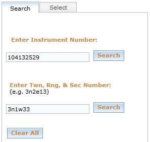
Search
for Instrument Number
Click in the search box and enter a known instrument
number. Click the ![]() button.
button.
If found, the map will zoom to the area of a full section and the point will be highlighted (selected) in yellow in the center of the map.
Click the highlighted point and a label box will be displayed with the Instrument Number, Recorded Date, Surveyor, Township/Range/Section which the record was recorded for, and the GCDB Number.
If the instrument number that was found was marked as conflicting, the Instrument Number will be displayed in Red. There will also be a scroll bar on the left side of the label box. Scroll down to view the comment field which will have some details about the source of the conflicting information.
Clicking on the Instrument number will open the .PDF document in a new window, which may be printed or saved as needed.
Clicking the ![]() button will unselect the point. Note that Clear All will only unselect the
point. It will not clear the number from
the search box.
button will unselect the point. Note that Clear All will only unselect the
point. It will not clear the number from
the search box.
Close the label box by clicking on the "x" in the upper right corner of the label box.
It is possible to have more than one instrument number selected; however there can only be one label box open at a time. Each document should open in a new window, but if there are problems, try left-clicking on the Instrument Number and selecting "Open in New Window" or "Open in New Tab".
Zoom
to Township/Range/Section
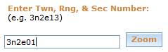
Click in the search box and enter the Township Range Section in the format 3N2E1. The section is not always two digits. Entering 3N2E01 will return an error "Not Found".
Click the ![]() button.
The map will zoom to fill the display with the chosen section. This function will only work with
Township/Range/Sections in Ada County.
Trying to find 5N2E15 will return an error "Sorry, No Result
Found"
button.
The map will zoom to fill the display with the chosen section. This function will only work with
Township/Range/Sections in Ada County.
Trying to find 5N2E15 will return an error "Sorry, No Result
Found"
Clicking the ![]() button after this operation will unselect any
selected points, but it will not clear the Township Range Section Search box.
button after this operation will unselect any
selected points, but it will not clear the Township Range Section Search box.
Select
Tab
This tab allows users to select groups of corner records for viewing.
The Select Tab has two buttons. Select Records & Clear Selection.
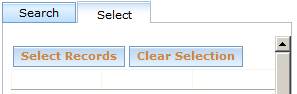
Selection is made by clicking the ![]() button.
Click and hold down the left mouse button to start, and draw a box
around the corner that the desired records are located on. Release the button when a box of the desired
size is achieved. Try to limit the
selection to a single corner (+/- 200 feet or so).
button.
Click and hold down the left mouse button to start, and draw a box
around the corner that the desired records are located on. Release the button when a box of the desired
size is achieved. Try to limit the
selection to a single corner (+/- 200 feet or so).
A list will display of the Instrument Number & Surveyor. The list of records may be sorted by clicking on any of the column labels in either ascending or descending order.
The instrument number of any corner records that are included in the selection which are conflicting (see Document Errors) will be displayed in Red.
Move the cursor over the list panel and click on the panel to make sure that the focus is on that panel. Holding the cursor over the instrument numbers of conflicting corners will display a comment field which will have some details about the source of the conflicting information.
Clicking on the document link will open the .PDF document in a new window, which may be printed or saved as needed. The only limitation to the number of open record documents in new windows is your system configuration and memory limitations.
Caution. Drawing a really big box with lots of points is guaranteed to generate a list that is confusing and un-useable.
Clicking the ![]() button will unselect the points and clear the
selection table. Click the
button will unselect the points and clear the
selection table. Click the ![]() button
again to select a new corner.
button
again to select a new corner.
History
The original CPF imaging project begun in September of 1998 and completed in February 2001, scanned the recorded corner record documents to .CAL image files, which were updated via a download available monthly from the Ada County Surveyors web site. The files were indexed by software developed by SV Image Information Systems, and viewed by a free reader (SV Reader). While the software was developed primarily for distributing plan sets to contractors, it worked well for viewing the corner records but had limitations on the types of files that could be included and would not work with color images.
Although the software had some advanced features, it was not fully utilized by Ada County.
From November 2007 to May of 2011, all of the image file updates were added to the project as single page .TIF files in CCITT Fax Group 4 format, which eliminated conversion to the .CAL file format.
As of the conversion date in May of 2011, the Ada County Surveyor maintained 6545 records and 6726 image files, in about 6.42 GB
5963 Files, representing 9.32 GB
Project
Description
In an effort to reduce the time it took for the County Surveyor's staff to enter and convert data, and improve the efficiency for the surveyors to find corner records it was decided to convert everything to a map based project. Text based searches were eliminated.
Most of the data in the original Access database was imported to the mapping environment, which resulted in the elimination of several hundred duplicate records which were required for indexing corners along township/range lines. This also fixed the problem where a duplicate record that my have been required was not found because it was not entered, or entered incorrectly.
While it fixed some problems, we were guaranteed to introduce some new ones. By virtue of the way the points were imported, a large portion of the points were off of the intended location. In some cases this was a long, long way. The only advantage was that it was instantly recognizable that there was something seriously wrong. While this map has been extensively checked for errors, there is no such thing as "error free" when it comes to GIS mapping. If you find a real blunder, please do us the courtesy of letting us know about it, instead of referring it to others for entertainment and amusement. See Mapping Errors.
The file size increased slightly with the conversion to the PDF format, however we hope that being able to have all of the pages associated with one instrument number compiled into one document makes it worth the slightly longer download time. We chose not to include all of the individual corner records filed on a single corner into one document, due to the fact that the old records were only valuable as a historical reference in case something did not fit. It also made error correction difficult, as swapping pages was very time consuming. In most cases, the surveyor is only looking for the latest recording. However, you do have the option to open all of the instrument documents at the same time, if you think you can do so without causing your system to crash.
Credits
This map is a cooperative effort of several departments within Ada County. We wish to thank the following individuals who had a large part in making this web page possible.
Rick Fisher – Programmer Analyst / Ada County Information Technology
Todd Buchanan – GIS Manager / Ada County Information Technology
Sherri Pillow – GIS Analyst / Ada County Information Technology
Christopher Rich – Ada County Recorder
We would also like to thank Kent Brown of AdaCanData.com for some of the image conversion work.
And especially David Couch, PLS (Ret.) and John Priester, PE, PLS (Ret.). Without their considerable efforts on the original imaging and database project in the past, we would have had to start from scratch.
Jerry Hastings, PLS – Ada County Surveyor
Glen Smallwood - Survey Technician / Ada County Development Services
May, 2011